Read carefully the reference material which climate factor. Climate and weather. Climate-forming factors
CLIMATE FORMING FACTORS
To reveal the conditions for climate formation, it is necessary to determine its causes. They are called climate-forming factors. The main climate-forming factors are shown in the diagram.
On Earth, given a homogeneous, sufficiently moist surface, differences in the climate of any part of the Earth would depend on the radiation balance and atmospheric circulation. In this case climatic zones would be located strictly zonally and their boundaries would coincide with parallels. In fact, climate zones are not so ideally expressed. This is explained by the fact that the climate of different parts of the Earth is formed under the influence of all climate-forming factors.
Solar radiation is the source of energy for all processes occurring in the atmosphere. Due to solar radiation, heat is transferred by the Sun through outer space. The spherical shape of the Earth determines climate differences depending on geographic latitude, and the inclined position of the Earth's rotation axis determines the seasonality of the climate. The circulation of air masses in the atmosphere affects the precipitation regime and the geography of its distribution on the globe, and air temperature.
To characterize the climate, it is very important to know how land and sea are distributed in a given place. The distance from the ocean shores to the interior of the continents affects the temperature and humidity regime and determines the degree of continentality of a given climate. Warm currents in the seas and oceans contribute to increased temperatures in coastal land areas and increased precipitation. Cold currents, on the contrary, lower the temperature on the outskirts of continents and prevent precipitation. The climate of the eastern and western coasts of South America, Australia and Africa, which are within the same tropical climate, is different. This is explained precisely by the presence of ocean currents there.
The impact on climate and relief is great. So, in the mountains different heights terrain above sea level climatic conditions vary; The climate is influenced by the direction of mountain ranges, which serve as an obstacle to wind and the invasion of air masses. Plains, on the contrary, allow continental or oceanic air masses to easily penetrate into neighboring areas.
Climate largely depends on the nature of the underlying surface, which refers to the components of the earth's surface that interact with the atmosphere. A forest, for example, reduces the daily temperature range of the soil and, therefore, the surrounding air. Snow reduces heat loss from the soil, but it reflects a significant amount sun rays, and the Earth therefore heats up slightly.
With the development of human society on Earth, a new factor has appeared that influences the planet’s climate. In cities, the air temperature is higher than in the surrounding areas. Air dust contributes to the formation of fogs and clouds, which leads to a reduction in the duration of sunshine and precipitation. Human economic activity sometimes has irreversible harmful influence on climate. For example, atmospheric pollution with sulfur dioxide and nitrogen oxides has given rise to the phenomenon of acid rain, which poisons soil and water bodies and destroys forests. These pollutants are transported over long distances by air masses and, together with precipitation, fall far from the sources of pollution. Only in the USA and Western Europe They have already destroyed more than 30 million hectares, which are the “lungs” of the planet. Acid rain also falls on Russian territory.
Another danger is the depletion of the ozone layer, especially over Antarctica. This layer protects our Earth from excess ultraviolet radiation. The cause of the destruction of the ozone layer is the production and use of freon in refrigeration units, in aerosols.
CLIMATE [Greek. klima inclination (of the earth's surface to the sun's rays)], statistical long-term weather regime, one of the main geographical characteristics of a particular area. The main features of the climate are determined
- incoming solar radiation
- air mass circulation processes
- the nature of the underlying surface.
Of the geographical factors influencing the climate of a particular region, the most significant are :
- latitude and altitude of the area,
- its proximity to the sea coast,
- features of orography and vegetation cover,
- presence of snow and ice,
- degree of air pollution.
These factors complicate the latitudinal climate zonation and contribute to the formation of local climate variations.
The concept of “climate” is much more complex than the definition of weather. After all, the weather can be directly seen and felt all the time, and can be immediately described in words or numbers from meteorological observations. To get even the most approximate idea of the climate of an area, you need to live in it for at least several years. Of course, you don’t have to go there; you can take many years of observational data from a meteorological station in this area. However, such material is many, many thousands different numbers. How to make sense of this abundance of numbers, how to find among them those that reflect the properties of the climate of a given area?
The ancient Greeks thought that climate depended only on the inclination of the sun's rays falling on the Earth. In Greek, the word climate means slope. The Greeks knew that the higher the sun above the horizon, the steeper the sun's rays fall on the earth's surface, the warmer it should be.
Sailing north, the Greeks found themselves in places with a colder climate. They saw that the sun at noon was lower here than at the same time of year in Greece. But in hot Egypt, on the contrary, it rises higher. We now know that the atmosphere transmits on average three-quarters of the heat of the sun's rays to the earth's surface and retains only one-quarter. Therefore, first the earth's surface is heated by the sun's rays, and only then does the air begin to heat up from it.
When the sun is high above the horizon (A1), a section of the earth's surface receives six rays; when lower, there are only four rays and six (A2). This means that the Greeks were right that heat and cold depend on the height of the sun above the horizon. This determines the difference in climate between the eternally hot tropical countries, where the sun is at noon all year round rises high and twice
or once a year stands directly overhead, and the icy deserts of the Arctic and Antarctic, where for several months the sun does not appear at all.
However, not at the same geographical latitude, even in the same degree of heat, climates can differ very sharply from each other. For example, in Iceland in January the average air temperature is almost 0°, and at the same latitude in Yakutia it is below -48°. In terms of other properties (amount of precipitation, cloudiness, etc.), climates at the same latitude can differ from each other even more than the climates of equatorial and polar countries. These climate differences depend on the properties of the earth's surface that receives the sun's rays. White snow reflects almost all the rays falling on it and absorbs only 0.1-0.2 parts of the brought heat, while black wet arable land, on the contrary, reflects almost nothing. Even more important for the climate is the different heat capacity of water and land, i.e. their different ability to store heat. During the day and summer, water heats up much more slowly than land and turns out to be colder. At night and in winter, water cools much more slowly than land, and thus turns out to be warmer.
In addition, it takes a lot of time to evaporate water in seas, lakes and wet land areas. a large number of solar heat. Due to the cooling effect of evaporation, the irrigated oasis is not as hot as the surrounding desert.
This means that two areas can receive exactly the same amount of solar heat, but use it differently. Because of this, the temperature of the earth's surface, even in two neighboring areas, can differ by many degrees. The surface of the sand in the desert on a summer day heats up to 80°, and the temperature of the soil and plants in the neighboring oasis turns out to be several tens of degrees colder.
In contact with soil, vegetation or water surface. The air either heats up or cools down depending on what is warmer - the air or the earth's surface. Since it is the earth's surface that first receives solar heat, it mainly transfers it to the air. The heated lowest layer of air quickly mixes with the layer lying above it, and in this way heat from the ground spreads higher and higher into the atmosphere.
However, this is not always the case. For example, at night the earth's surface cools faster than the air, and it gives off its heat to it: the heat flow is directed downward. And in winter, over the snow-covered expanses of the continents in our temperate latitudes and over the polar people, this process goes on continuously. The earth's surface here either does not receive solar heat at all, or receives too little of it and therefore continuously takes heat from the air.
If the air were motionless and there was no wind, then masses of air with different temperatures would rest over neighboring differently heated areas of the earth's surface. Their boundaries could be traced to the upper reaches of the atmosphere. But the air is constantly moving, and its currents tend to destroy these differences.
Let's imagine that air moves over a sea with a water temperature of 10° and on its way passes over a warm island with a surface temperature of 20°. Above the sea, the air temperature is the same as the water, but as soon as the flow crosses the coastline and begins to move inland, the temperature of its lowest thin layer begins to rise, and approaches the temperature of the land. Solid lines of equal temperatures - isotherms - show how heating spreads higher and higher in the atmosphere. But then the flow reaches the opposite shore of the island, enters the sea again and begins to cool - also from bottom to top. Solid lines outline the “cap” that is inclined and shifted relative to the island. warm air. This “cap” of warm air resembles the shape that smoke takes in strong winds.
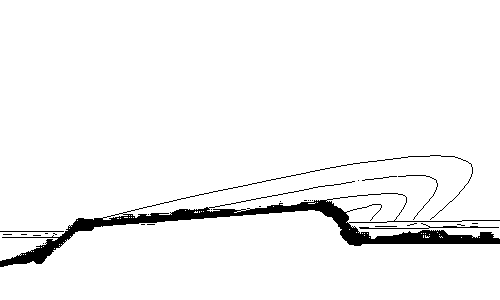 |
What we see in the figure is repeated everywhere over small and large differently heated areas. The smaller each such area, the lower the level in the atmosphere above it will be, to which the heating (or cooling) of the air flow will have time to spread. If an air current from the sea passes to a snow-covered continent and moves many thousands of kilometers above it, then it will cool several kilometers upward. If a cold or warm area extends for hundreds of kilometers, then its influence on the atmosphere can be traced only hundreds of meters upward; with smaller sizes, the height is even less.
There are three main types climates - large, medium and small.
The great climate is formed under the influence only of geographic latitude and the largest areas of the earth's surface - continents, oceans. It is this climate that is depicted on world climate maps. A large climate changes smoothly and gradually over large distances, at least thousands or many hundreds of kilometers.
The climatic features of individual areas with a length of several tens of kilometers (a large lake, a forested area, a large city, etc.) are classified as an average (local) climate, and smaller areas (hills, lowlands, swamps, groves, etc.) - to a small climate.
Without such a division it would be impossible to figure out which climate differences are major and which are secondary.
It is sometimes said that the creation of the Moscow Sea on the Moscow Canal changed the climate of Moscow. This is not true. The area of the Moscow Sea is too small for this.
Different influx of solar heat at different latitudes and unequal use of this heat by the earth's surface. They cannot fully explain to us all the features of climates if we do not take into account the importance of the nature of atmospheric circulation.
Air currents constantly transfer heat and cold from different regions of the globe, moisture from the oceans to land, and this leads to the emergence of cyclones and anticyclones.
Although the atmospheric circulation changes all the time and we feel these changes in weather changes, a comparison of different areas shows some constant local circulation properties. In some places, northern winds blow more often, in others - southern ones. Cyclones have their favorite paths of movement, anticyclones have theirs, although, of course, there are any winds in any place and cyclones are replaced by anticyclones everywhere. Cyclones cause rain.
Bibliography.
Ilyin M. Man and element. Ed. 4.M. “Young Guard” 1954.
Ruzalin G.I. The concept of modern natural science. M. 1997.
Mezentsev V.A. "Unusual phenomena in the atmosphere." M. Profizdat. 1959.
Galtsov A.P. How the weather is predicted. M., Voenizdat, 1954
Children's encyclopedia. Publishing house "Enlightenment" vol.1. 1967.
Determining the main climate-forming factors will be impossible without knowledge of what climate is, and these are frequently recurring weather patterns in a certain area that do not change over a long period of time.
Introduction
There is no one reason. This thesis is confirmed by the presence of not one, but several factors influencing the formation and evolution of climate on Earth. One or even two factors would form climatic zones that would have clear boundaries and coincide with parallels.
In reality, a completely different picture emerges: the climate zones on Earth are not so ideally expressed. This is explained by the fact that the climate in a certain area of land, for example, in Eurasia, was formed due to the combination of all climate-forming factors: astronomical, geographical and human influence on nature.
Astronomical or planetary factors
Astronomical or planetary factors include:
- level of solar radiation;
- circulation of air masses;
- moisture circulation;
- rotation of the Earth around the Sun and its axis.
The level of solar radiation affects the transfer of solar heat through space. The rotation of the Earth causes the formation of trade winds and monsoons, as well as various cyclones, which, in turn, affect air temperature, precipitation patterns and their distribution throughout the globe. The formation of different climatic zones depending on geographic latitude was made possible due to the spherical shape of our planet.
The movement of the Earth around the Sun is also very important factor: the inclined position of the planet’s rotation axis changes, and with it seasonal changes in weather conditions.
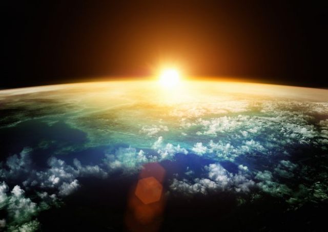
rice. 1. Astronomical climate-forming factors
Geographical factors
Geographic climate-forming factors include:
- latitude of place;
- relief;
- underlying surface;
- ocean currents.
The formation of climate in a certain area is influenced by the distribution of land and sea. For example, air temperature, humidity, and the degree of continental climate directly depend on the distance of the land from the ocean shores. For full description It is very important to know the climate and what the terrain is like in a given area. Mountains and the direction of mountain ranges are a serious barrier to the invasion of air masses. The steppe zone, on the contrary, facilitates the penetration of continental or oceanic air masses.
Currents in the oceans and seas also play an important role in climate formation. For example, warm currents contribute to increased temperatures and increased precipitation. Cold weather, on the contrary, affects a decrease in temperature and a reduction in precipitation. As for the underlying surface, which refers to the components of the earth's surface that interact with the atmosphere, its nature directly affects the formation of climate.

Fig.2. Geographic climate-forming factors
Human influence
Human influence on nature and climate is, one might say, a modern climate-forming factor. It became possible thanks to the development of human society, and its influence is not always a plus. For example, in large cities there is an increase in air temperature, and dust causes fog and smog, which prevent the penetration of sunlight and increase precipitation. In addition, air pollution has led to the appearance of so-called acid rain, which “contaminates” the soil and water bodies.
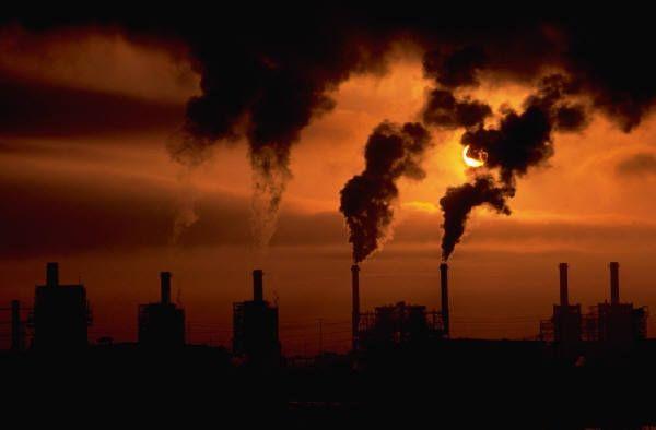
Fig.3. The influence of human economic activity on the planet's climate
The destruction of the ozone layer is another scourge of our time, generated by scientific and technological progress. Excessive use of freon, which can be found in various aerosols and refrigeration units, poses a huge danger to the planet - excess ultraviolet radiation.
What have we learned?
The climate of our home planet directly depends on the combination of all factors, which, in turn, influence the total amount of solar radiation on Earth, as well as its distribution across hemispheres, continents and seasons. So, let’s once again list all the climate-forming factors: astronomical, geographical and human influence. This article helps to consolidate the material studied in geography, and will help in preparing homework for a lesson in 7th grade.
There are three main climate-forming factors, and in addition to them - additional factors that can influence climate. But the main factors determine the climate of any point on the globe.
Main climate factors
The main climate factors include terrain, solar radiation and atmospheric circulation. The terrain qualitatively changes the influence of other factors on the climate.
This is due to the fact that mountain ranges and elevations have specific temperature regime, as well as precipitation patterns. Slopes and ridges can reflect significant amounts of solar energy, creating huge shaded mountain areas.
There are high mountain peaks that are completely covered with snowfields and ice, regardless of the time of year. Mountains also act as barriers to the movement of air fronts and masses, and for this reason they often become the boundaries of climatic regions.
There are many areas on the surface of our planet where precipitation is very frequent and large, and there are areas where there is very little precipitation. For example, Central Asia is considered a dry region, as mountain systems rise along the outskirts of this region.
Solar radiation
This is the factor that determines the supply of solar energy to different surfaces land. Geographic latitude determines the amount of heat. This is an extremely important factor, since it is thanks to a certain amount Heat powers almost all life processes on the planet.
And other climate indicators directly depend on solar radiation - cloudiness and pressure, atmospheric circulation and precipitation.
Atmospheric circulation
As a factor in the formation of climate, atmospheric circulation determines the movement of air masses along the earth's surface and vertically. And inter-latitudinal air exchange occurs precisely thanks to this process. Air masses are carried by clouds, which in turn determine precipitation.
They redistribute pressure, humidity and air temperature and form wind currents. Climate conditions change with changes in altitude, this is clearly felt in the mountains - with increasing altitude, the temperature decreases, humidity decreases, precipitation increases and atmospheric pressure drops.
These changes make it possible to distinguish climate zones for the mountains. Flat land surfaces and the surface of the World Ocean do not have a significant influence or direct impact on the main climate-forming factors. They do not distort the movement of air masses, their speed and directions.
Climate-forming factors in different regions
There are factors that influence the type of climate that are unique to certain regions of the planet. For example, the distance of a particular territory from the seas and oceans, the general distribution of sea and land.
There is a difference between maritime air masses that are continental, depending on how far into the continents they move. The amount of precipitation also depends on this.