What is environmental monitoring. Lesson "The concept of monitoring environment. Types and methods of monitoring. Environmental monitoring. Production environmental monitoring
14.1 The concept of environmental monitoring. Classification.
14.2 Evaluation of the actual environment of the environment
14.1 The concept of environmental monitoring. Classification
To identify changes in the state of the biosphere under the influence of human activity, a system of observations is necessary. Such a system is currently generally accepted with monitoring.
Monitoring They call the system of repeated observations of one or more elements of the environment in space and in time with certain purposes and in accordance with the previously prepared program. The concept of environmental monitoring was first introduced by R. Yennom in 1972 at the Stockholm UN Conference.
Monitoring includes the following main directions Activities:
Observations of factors acting on the environment, and for the state of the environment;
Assessing the actual state of the natural environment;
Forecast of the state of the natural environment. And evaluating this state.
Thus, monitoring is a multi-purpose information system of observations, analysis, diagnosis and forecast state of a natural environment that does not include environmental quality management, but giving the necessary information for such management.
Objectives of environmental monitoring
Scientific and technical support of observation, assessment of the forecast of the state of the environment;
Observations of the sources of contaminants and the level of environmental pollution;
Identifying sources and factors of pollution and evaluation of their environmental impact;
Evaluation of the actual environment of the environment;
Forecast of environmental status and ways to improve the situation.
Monitoring classification.
Observation scale;
On observation objects;
In terms of pollution of observation objects;
By factors and sources of pollution;
According to observation methods.
Observation scale
|
Name level monitoring |
Monitoring organizations |
|
Global |
Interstate monitoring system ambient |
|
National |
State system of environmental monitoring of the territory of Russia |
|
Regional |
Regional, regional environmental monitoring systems |
|
Local |
City, District Environmental Monitoring Systems |
|
Detailed |
Environmental monitoring systems of enterprises, deposits, factories, etc. |
Detailed monitoring
The lower hierarchical level is the level of detail of the environment, implemented within the territories and scales of individual enterprises, plants, individual engineering structures, economic complexes, deposits, etc. Detailed environmental monitoring systems are the most important link in the higher rank system. Their association in a larger network forms a local level monitoring system.
Local monitoring (impact)
It is carried out in highly polluted places (cities, settlements, water bodies, etc.) and focused on the source of pollution. IN
communication contacts here are usually present in significant quantities of all major substances that make up emissions into the atmosphere and reset into water bodies. Local systems, in turn, are combined into even larger - regional monitoring systems.
Regional monitoring
It is carried out within a region, taking into account the natural nature, the type and intensity of man-made impact. Regional environmental monitoring systems are combined within one state into a single national monitoring network.
National monitoring
Monitoring system under one state. Such a system differs from global monitoring not only by scale, but also in the fact that the main task of national monitoring is to obtain information and assess the state of the environment in national interests. In Russia, under the guidance of MPR. As part of the UN Environmental Program, the task is to combine national monitoring systems into a single interstate network - "Global Environmental Monitoring Network" (GSM)
Global monitoring
PURPOSE GSMOS - monitoring for changes in environmental change on Earth as a whole, globally. Global monitoring is a system for tracking a condition and predicting possible changes in global processes and phenomena, including anthropogenic effects on the biosphere as a whole. GSOS is engaged in global climate warming, the problems of the ozone layer, the preservation of forests, droughts, etc. .
Observation objects
Atmospheric air
in settlements;
different layers of the atmosphere;
stationary and mobile sources of pollution.
Underground and surface water bodies
fresh and salty waters;
mixing zones;
regulated water bodies;
natural reservoirs and watercourses.
Geological environment
soil layer;
Biological monitoring
plants;
animals;
ecosystems;
Monitoring snow cover
Monitoring radiation background.
The level of pollution of observation objects
Background (basic monitoring)
These are observations of environmental objects in conditionally clean natural zones.
2. Impact
Focused on the source of pollution or a separate pollutant effect.
By factors and sources of pollution
1. Ingradient monitoring
This is a physical impact on the environment. This is radiation radiation, thermal impact, infrared, noise, vibration, etc.
2. Ingredient monitoring
This is the monitoring of a separate pollutant.
According to observation methods
1. Contact Methods
2. Remote methods.
Environmental monitoring is a complex of observation, which is also as a state, its assessment and forecast of the changes occurring in it under the influence of both anthropogenic and natural factors.
As a rule, on any territory, such studies are always conducted, but services, they involved, belong to various departments, and their actions are not coordinated by any of the aspects. For this reason, before monitoring the environment, it is a priority task: to decide on the ecological and economic area. The next step is to choose information regarding the state of the medium. You also need to make sure that the received data is quite enough in order to make the right conclusions.
Types of environmental monitoring
Since there are many tasks of various levels during observation, at one time it was proposed to distinguish between three directions:
Sanitary-hygienic;
Natural economic;
Global.

However, in practice it turned out, the approach does not allow to clearly define the zoning and organizational parameters. It is impossible to accurately divide the functions of observation of the environment.
Environmental monitoring: Subsystems
The main subspecies of the surveillance in the environment is:
This service is engaged in the control and forecast of climate fluctuations. It covers ice cover, atmosphere, ocean and other parts of the biosphere affecting its formation.
Geophysical monitoring. This service analyzes the data and data of hydrolylists, meteorologists.
Biological monitoring. This service monitors the environmental pollution affects all living organisms.
Monitoring the health of residents of a territory. This service observes, analyzes and predicts the population.

So, in general, environmental monitoring is as follows. The environment (or one object is it) is selected, its parameters are measured, and then information is transmitted. After that, the data is processed, their overall characteristic is given at the current stage and forecasting for the future.
Wednesday observation levels
Environmental monitoring is a multi-level system. Ascending it looks like this:
Detailed level. Monitoring is implemented in small sites.
Local level. This system is formed when parts of the detailed monitoring are combined into one network. That is, it is conducted on the territory of the district or a big city.
Regional level. It covers the territory of several regions within the same area or edge.
National level. It is formed united within the country of the regional monitoring system.
Global level. It combines the monitoring systems of several nations. His task is to follow the state of the environment around the world, predict its changes occurring, including, as a result of influence on the biosphere.
Observation program
Environmental monitoring is scientifically justified and has its own program. It specifies the purpose of it, specific steps and implementation methods. The main points of which are the monitoring are as follows:
List of objects that are controlled. Accurate indication of their territory.
The list of indicators of the leading control and permissible limits of their changes.
And finally, the temporary framework, that is, with which periodicity must be selected, and when the data should be provided.
Environmental monitoring
Introduction
The environmental monitoring system should accumulate, systematize and analyze information:
on the state of the environment;
On the causes of the observed and probable changes of the state (that is,
sources and factors of impact);
on the admissibility of changes and loads on Wednesday as a whole;
on existing reserves of the biosphere.
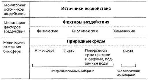
Thus, the environmental monitoring system includes observations of the state of the elements of the biosphere and observation of sources and factors of anthropogenic effects.
In accordance with the definitions and the functions assigned to the system, monitoring includes three main activities:
observations of factors of impact and environment of the environment;
evaluation of the actual state of the medium;
forecast of the state of the environment and evaluation
predicted state.
It should be taken into account that the monitoring system itself does not include environmental management activities, but is a source of information necessary for making environmentally significant information solutions.
The main tasks of environmental monitoring:
observation of anthropogenic sources;
observation of anthropogenic factors;
Observation of the state of the natural environment and what is happening in it
processes under the influence of anthropogenic factors;
Evaluation of the actual state of the natural environment;
Forecast of changes in the state of the natural environment under the influence of factors
Anthropogenic impact and assessment of the predicted state
Natural medium.
Environmental environmental monitoring can be developed at the level of industrial facility, city, regions, edges, republics as part of the Federation.
The nature and mechanism of generalizing information on the environmental situation during its movement on the hierarchical levels of the environmental monitoring system are determined by the concept of an information portplace of the environmental situation. The latter represents a combination of graphically represented spatially distributed data characterizing the environmental situation on a certain territory, together with the cardinox terrain.
When developing a project for environmental monitoring, the following information is necessary:
The sources of the flow of pollutants into the environment - emissions of pollutants into the atmosphere of industrial, energy, transport and other-wheeling hazardous substances and spill of liquid pollutants and hazardous substances, etc.;
Transfers of pollutants - the processes of atmospheric transfer; processes of transfer and migration in the aquatic environment;
The processes of landscape-geochemical redistribution of pollutants - the migration of pollutants in the soil profile to the level of groundwater; Migration of pollutants in landscape-geochemical pairing taking into account geochemical barriers and
biochemical circles; biochemical circulation, etc.;
Data on the status of anthropogenic sources of contamination is the power of the source of pollution and its location, hydrodynamic conditions for the enactment of pollution into the environment.
It should be taken into account that the monitoring system itself does not include environmental management activities, but is a source of information necessary for making environmentally significant information solutions. The term control that is often used in the Russian-speaking literature to describe the analytical definition of certain parameters (for example, the control of the composition of atmospheric air, water quality control of water), should be used only with respect to activities involving the adoption of active regulatory measures.
"Environmental Control" is the activities of state bodies, enterprises and citizens to comply with environmental norms and rules. Distinguish state, production and public environmental control.
The legislative frameworks of environmental control are governed by the Law of the Russian Federation "On the Protection of the Environmental Environment";
1. Environmental control sets its tasks: monitoring
the state of the environment and its change under the influence of economic and
other activities; verification of execution of plans and measures to protect
Nature, rational use of natural resources, improvement
Environmental Environment, Compliance
environmental legislation and environmental standards of the environmental environment.
2. Environmental control system consists of civil service
observations of the state of the environment, state,
Production, public control. So in
Socialist Legislation State Monitoring Service
It is actually defined as part of the overall environmental control system.
Classification of environmental monitoring
There are various approaches to the monitoring classification (by the nature of the tasks solved, according to the levels of the organization, by natural environments, which are observed). Reflected in Fig. 2 Classification covers the entire block of environmental monitoring, observing the changing abiotic component of the biosphere and the response of ecosystems to these changes. Thus, environmental monitoring includes both geophysical and biological aspects, which determines the wide range of research methods and methods used in its implementation.
 As already noted, the implementation of environmental monitoring in the Russian Federation is responsible for various public services. This leads to some uncertainty (at least for the public) in relation to the distribution of the duties of the civil service and the availability of information about the sources of impact, the state of the environment and natural resources. The situation exacerbates periodic restructuring of ministries and departments, their mergers and divisions.
At the regional level, environmental monitoring and / or control is usually charged:
Committee on Ecology (Observation and Emission Control and Discharges
existing enterprises).
Committee on Hydrometeorology and Monitoring (impact, regional and partly
background monitoring).
Sanitary and epidemiological service of the Ministry of Health (state of workers, residential and
Recreation zones, drinking water and food quality).
Ministry of Natural Resources (first of all geological and
Hydrogeological observations).
Enterprises carrying out emissions and discharges to the environment
(Observation and control over your own emissions and discharges).
Various departmental structures (divisions of the Ministry of Agricultural Production, MINECS,
Ministry of Powered, enterprises of the water-sewer farm, etc.)
In order to effectively use the information already received by public services, it is important to know exactly the functions of each of them in the field of environmental monitoring (TAOOL_ 2).
In the system of official environmental monitoring, powerful professional forces are involved. Do you need a public environmental monitoring? Is there a place for it in the general monitoring system existing in the Russian Federation?
In order to answer these questions, consider the levels of environmental monitoring adopted in Russia (Fig. 4).
 Ideally, the impact monitoring system should accumulate and analyzes the detailed information on specific sources of pollution and their environmental impact. But in the system established in the Russian Federation, information about the activities of enterprises and the state of the medium in the zone of their impact is largely averaged or based on the statements of the enterprises themselves. Most of the available materials reflect the nature of the scattering of pollutants in the air and in water, installed using model calculations, and the results of measurements (quarterly - on water, annual or rare - by air). The state of the environment is fully described only in large cities and industrial zones.
In the field of regional monitoring, observation is mainly Roshydrometha, which has an extensive network, as well as by some agencies (AgrochimSlug of the Ministry of Association, a water-sewer service, etc.) and, finally, there is a network of background monitoring carried out under the MAV program (Man and BioSphere). Almost not covered by the network of observations remains small cities and numerous settlements, the overwhelming majority of diffuse sources of pollution. Monitoring the state of the aquatic environment, organized, above all, Roshydromet and, to some extent, sanitary-epidemiological (SES) and utilities (Vodokanal) services, does not cover the overwhelming majority of small rivers. At the same time knows what< загрязнение больших рек в значительной части обусловлено вкладом разветвленной сети их притоков и хозяйственной деятельностью в водосборе. В условиях сокращения общего числ; постов наблюдений очевидно, что государство в настоящее время не располагает ресурсами для организации сколько-нибудь эффективной системы мониторинга состояния малых рек.
Thus, white spots are clearly indicated on the environmental card, where systematically! Observations are not conducted. Moreover, within the framework of the Network of State Environmental Monitoring, there are no prerequisites for their organization in these places. It is these white spots that can (and often should) become objects of public environmental monitoring. Practical orientation of monitoring, concentration of efforts on local problems in combination with a thoughtful scheme and the correct interpretation of the data obtained allow you to effectively use resources from the public. In addition, these features of social monitoring create serious prerequisites for organizing a constructive dialogue aimed at consolidating the efforts of all participants. Global environmental monitoring system. In 1975 A global environmental monitoring system (GSMOS) was organized under the auspices of the UN, but it began to effectively act only recently. This system consists of 5 interconnected subsystems: the study of climate change, long-range transfer of pollutants of substances, hygienic aspects of the environment, the world's ocean and sushi resources. There are 22 networks of existing global monitoring stations, as well as international and national monitoring systems. One of the main ideas of monitoring is to enter a fundamentally new level of competence during the decision-making of local, regional and global scales.
The concept of public environmental expertise originated in the late 80s and quickly gained widespread. The initial interpretation of this term was very wide. Under independent environmental expertise, they implied a variety of ways to obtain and analyze information (environmental monitoring, environmental impact assessment, independent research, etc.). Currently, the concept of public environmental impact assessment is determined by law. "Environmental Expertise" is to establish compliance with the planned economic and other activities to the environmental requirements and admissibility of the implementation of the object of examination in order to prevent the possible adverse effects of this activity on the environment and related social, economic and other consequences of the implementation of the environmental impact facility.
Environmental expertise may be state and public. Community environmental expertise is held on the initiative of citizens and public organizations (associations), as well as on the initiative of local self-government bodies with public organizations (associations).
Objects of state environmental examination are:
Projects of the General Plans for the Development of Territories,
All types of urban planning documentation (for example, master plan, building project),
Projects for the development of the sectors of the national economy,
Projects of interstate investment programs, projects of complex schemes for the protection of nature, protection and use schemes for natural resources (including land use and forest management projects, materials substantiating the translation of forest lands in non-oil),
Projects of international treaties,
Materials Justification of licenses for activities capable of environmental impact,
Technical and economic justification and projects of construction, reconstruction, expansion, technical re-equipment, conservation and liquidation of organizations and other objects of economic activity, regardless of their estimate cost, departmental affiliation and ownership forms,
Projects of technical documentation for new techniques, technology, materials, substances, certified goods and services.
Public environmental expertise may be held in relation to the same objects as the state environmental impact assessment, with the exception of objects whose information is compiled by the state, commercial and (or) secrecy protected by law.
The purpose of the environmental examination is to prevent the possible adverse effects of environmental activities and related socio-economic and other consequences related to them.
According to the law, environmental expertise is based on the principle of the presumption of the potential environmental hazard of any planned economic or other activities. This means that the duty of the customer (the host of the planned activity) is the forecast of the impact of the environmental activities and the rationale for the admissibility of this impact. The customer is also obliged to provide for the necessary measures to protect the environment and it is on it that lies the burden of evidence of the environmental safety of the planned activity. Foreign experience testifies to the high economic efficiency of environmental impact assessment. The United States Environment Agency carried out a selective analysis of the conclusions on the impact on Wednesday. In half of the studied cases, a decrease in the total value of projects was noted through the implementation of constructive environmental activities. According to the International Bank for Reconstruction and Development, the possible increase in the value of projects related to the implementation of environmental impact assessment and follow-up in working projects of environmental restrictions pays off on average in 5-7 years. According to Western specialists, the inclusion of environmental factors in the decision-making process is still 3-4 times cheaper than the installation of cleaning equipment. Today, the network of observation of exposure sources and for the state of the biosphere covers the entire globe. The Global Environmental Monitoring System (GSM) was created by the joint efforts of the World Community (the main provisions and objectives of the Program were formulated in 1974 at the first intergovernmental monitoring meeting).
The priority was recognized by the organization of monitoring pollution of the environment and causing it factors impact.
The monitoring system is implemented on several levels that are consistent with specially designed programs:
impact (study of strong exposure to the local scale of B- and);
regional (manifestation of problems of migration and transformation of pollutants, joint impact of various factors characteristic of the regional economy - P);
Background (based on biosphere reserves, where all economic activities are excluded - f).
The program of impact monitoring can be directed, for example, to study the discharges or emissions of a particular enterprise. The subject of regional monitoring, as follows from its name itself, is the state of the environment within the limits of this or that region. Finally, the background monitoring carried out within the framework of the international program of the person and the biosphere, aims to fix the background state of the environment, which is necessary for further estimates of the levels of anthropogenic impact.
Observing programs are formed on the principle of choosing pollutants and the corresponding characteristics. The definition of these contaminants in the organization of monitoring systems depends on the purpose and tasks of specific programs: so, in a territorial scale, the priority of government monitoring systems is given to cities, sources of drinking water and spawning places of fish; With respect to media observations, the atmospheric air and water of fresh reservoirs deserve. The priority of the ingredients is determined taking into account the criteria reflecting the toxic properties of pollutants, the volumes of their enaving environment, the features of their transformation, the frequency and the magnitude of the impact on humans and the biota, the possibility of measuring the measurement and other factors.
State environmental monitoring
The GSMOS is based on national monitoring systems that operate in various countries in accordance with both international requirements and specific approaches that have developed historically or caused by the most acute environmental problems. The international requirements that national GSMOS participating systems include common principles of program development (taking into account priority impact factors), the obligation of observations of objects that have global importance, transmitting information to the GSMOS center. On the territory of the USSR in the 70s, a nationwide observation service and environmental monitoring (OGSNN), built according to the hierarchical principle, was organized on the basis of the hydrometeor service.
 Fig. 3. Tray of information in the Hierarchical system of OGSNA
In the treated and systematized form, the obtained information is presented in cadastral publications, such as the annual data on the composition and quality of sushi surface water (by hydrochemical and hydrobiological indicators), the annual of the state of the atmosphere in the cities and industrial centers, etc. until the end of the 80s, all cadastral The publications had a vulture for official use, then for 3-5 years have been open and accessible in the central libraries. To date, massive compilations of the annual data type ... in the library practically do not come. Some materials can be obtained (acquired) in regional divisions of Roshydromet.
In addition to the OGSNN, which is part of the Roshydromet (Federal Service of Russia on Hydrometeorology and Environmental Monitoring), environmental monitoring is carried out by a number of services, ministries and departments.
Unified State System of Environmental Monitoring
In order to radically increase the efficiency of work on the preservation and improvement of the state of the environment, ensuring the environmental safety of a person in the Russian Federation "On the establishment of a unified state system of environmental monitoring" (HSEM).
HSEM solves the following tasks:
Development of observation programs for the state of the environment (OPS) in Russia, in its individual regions and districts;
Observation organization and measurements of indicators of environmental monitoring objects;
ensuring the accuracy and comparability of observational data both in separate regions and districts and throughout Russia;
collection and processing of observation data;
Organization of storage of observation data, conducting special data banks that characterize the environmental situation in Russia and in its separate areas;
harmonization of banks and the bases of environmental information with international environmental information systems;
Assessment and forecast of the state of objects of OPS and anthropogenic effects on them, natural resources, responses of ecosystems and public health to change the state of the OPS;
organization and conduct of operational control and precision changes in radioactive and chemical pollution as a result of accidents and disasters, as well as predicting the environmental situation and assess the damage caused by the OPS;
ensuring the availability of integrated environmental information with a wide range of consumers, including population, social movements and organizations;
Information support authorities for the state of OPS, natural resources and environmental safety;
development and implementation of a unified scientific technical policy in the field of environmental monitoring;
Creation and improvement of organized, legal, regulatory, methodological, methodological, information, software and mathematical, hardware and technical support of the operation of the HSEMM.
HSEM in turn includes the following main components:
monitoring sources of anthropogenic environmental impact;
monitoring the contamination of the abiotic component of the environment;
monitoring the biotic component of the environment;
Socio-hygienic monitoring;
Ensuring the creation and functioning of environmental information systems.
At the same time, the distribution of functions between the central bodies of the executive federal government is carried out as follows.
Goscomecology: coordination of the activities of ministries and departments, enterprises and organizations in the field of OPS monitoring; Organization of monitoring sources of anthropogenic environmental impact and their direct impacts; Organization of monitoring of animal and plant world, monitoring ground fauna and flora (except forests); ensuring the creation and operation of environmental information systems; Maintaining with interested ministries and departments of data banks on environmental environment, natural resources and their use. Roshydromet: Organization of monitoring of the state of the atmosphere, surface water, marine medium, soil, near-earth outer space, including complex background and space monitoring of the state of the ambient environment; Coordination of the development and operation of departmental subsystems background monitoring
Pollution OPS; Maintaining the State Fund for Pollutinating Environmental Environment.
Romkoze: Land Monitoring.
Ministry of Natural Resources: Monitoring subsoil, including monitoring groundwater and dangerous geological processes; Monitoring the aquatic environment of water systems and structures in the places of waterboat and discharge of wastewater. Roskomrybolovya: Monitoring of fish, other animals and plants.
Rosleshoz: forest monitoring.
Roskartography: Implementation of the topographic and geodesic and cartographic support of HSEM, including the creation of digital, electronic maps and geographic information systems. Gosgortkhnadzor of Russia: coordination of the development and functioning of the subsystems for monitoring the geological environment related to the use of subsoil resources at the enterprises of extractive industries; Monitoring of industrial safety (with the exception of objects of the Ministry of Defense of Russia and Minatom Russia). Goskomepidadzor of Russia: monitoring the impact of habitat factors for the health of the population. Ministry of Defense of Russia; monitoring of OPS and sources of influence on it at military facilities; Ensuring HSEMM means and systems of military equipment of dual use. Goskomsever of Russia: participation in the development and functioning of HSEM in the areas of the Arctic and the Far North. Environmental monitoring technologies (EEM) covers the development and use of funds, systems and methods of observations, evaluating and developing recommendations and managerial impacts in the natural and technological sphere, the forecasts of its evolution, the energy-ecological and technological characteristics of the production sphere, biomedical and sanitary Hygienic conditions of human and biota existence. The complexity of environmental problems, their multidimensity, closely communicating with key sectors of the economy, defense and ensuring the protection of health and well-being of the population requires a single systematic approach to solving the problem. Monitoring as a whole is created to prevent various environmental problems, as well as the destruction of ecosystems.
Extermination of species and destruction of ecosystems
The impact of a person on the biosphere led to the fact that very many types of animals and plants or disappeared completely, or became rare. In mammals and birds, which are easier to consider than invertebrates, you can bring completely accurate data. For the period from 1600 to the present, a person was exterminated by 162 species and subspecies of birds and 381 like the same fate threatened; Among the mammals disappeared, at least a hundred species and 255 are on the way to disappearance. The chronology of these sad events is not difficult to trace. In 1627, the last round was died in Poland, the ancestor of our major cattle. In the Middle Ages, this animal could still be found in France. In 1671, DRONT disappeared from the island of Mauritius. In 1870-1880 The boots were destroyed by two types of South African zebras - Burcherlova Zebra and Kvagga. In 1914, the last representative of the wandering pigeon died in the zoo of the city of Cincinnati (USA). It would be possible to bring a large list of animals under threat of destruction. Miraculously survived American bison and European bison; The Asian Lion has been preserved only in one of the forests of India, where it remains only 150 individuals; In France, even fewer bears and predatory birds are becoming every day.
The disappearance of species today
Mailing is a natural process. However, since the appearance of agriculture, about 10 thousand years ago, the speed of the disappearance of species increased sharply as people resettles around the globe. For approximate estimates, between 8000 a year BC The average rate of disappearance of mammals and birds has increased 1000 times. If you include the speed of the disappearance of plant and insect species, then the rate of extinction in 1975 was several hundred species per year. If you take the lower limit of 500,000 disappeared species, then by 2010, 20,000 species per year will disappear as a result of anthropogenic activities, i.e. A total of 1 view every 30 minutes - a 200-fold increase in the rate of extinction in just 25 years. Even if the average speed of disappearance at the end of the 20th century is to take 1000 per year, the total losses will be incomparable with the great mass extinction of the past. The greatest public is subject to the disappearance of animals. But the disappearance of plants from an ecological point of view is more important, as most animal species depends directly or indirectly. It is estimated that more than 10% of plants of the world today are under threat of disappearance. By 2010, 16 to 25% of all types of plants will disappear.
Principles of the integrated characteristics of the state of pollution of the natural environment
The comprehensive characteristic of the state of pollution comes from the concept of comprehensive environmental analysis. The main and prerequisite for this concept is to consider all the main parties to interactions and connections in the natural environment and accounting for all aspects of pollution of natural objects, as well as the behavior of pollutants (SV) and the manifestations of their impact.
Program of a comprehensive study of ground ecosystem pollution
In the conditions of an increasing load of industrial civilization, the pollution of the medium turns into a global factor that determines the development of the natural environment and human health. The prospects for such a development of society are destructive for the existence of a developed civilization. The proposed program makes it possible to actually assess the complex of problems related to the environmental monitoring organization and plan work on the study of pollution of a specific territory. As part of the program, the task is also set to show that environmental pollution is actually actual and universally common environmental factor.
The pollution of the medium is an objective reality and it is impossible to be worried. (Example - Radiophobia, i.e. mental illness associated with constant fearing radioactive infection). It is necessary to learn to live in the changed conditions so as to reduce the impact of pollution on their health and health of their neighbors. The formation of environmental convention is the main way to deal with the conservation and improvement of the environmental quality. Usually in school, out-of-school and university programs of applied ecology, the problems of pollution of water bodies and the world's ocean are widely understood. Particular attention is paid to the assessment of the state of water bodies and local watercourses on environmental and hydrochemical indicators. There are numerous programs to assess the ecological state of water bodies. This question is well developed in the methodical and scientific plan.
Ground ecosystems, the inalienable component of which both people are less studied and in training courses are less common as model objects. This is due to a significantly more complex organization of ground biota. When we consider terrestrial ecosystems, natural or largely modified by humans, the number of internal and external relationships increases sharply, the source of contamination or other impact becomes more blurred, and its impact is identified more difficult, compared with water ecosystems. The boundaries of ecosystems and territories exposed to anthropogenic effects are blurred. However, it is the state of terrestrial ecosystems, i.e. Sushi territory, most noticeably and significantly affects the quality of our life. The purity of the air that we breathe, food and drinking water, which we consume, ultimately related to the state of pollution of sushi ecosystems. From the mid-50s, pollution has adopted a global scale - anywhere in the planet, you can now detect toxic products of our civilization: heavy metals, pesticides and other toxic organic and inorganic compounds. It took 20 years for the awareness of scientists and governments of the countries of the world the need to create a global pollution service for the natural environment.
Under the auspices of the UN program on environmental issues (UNEP), it was decided to establish a global environmental monitoring system (GSMOS) with a focal point in Nairobi (Kenya). At the First Intergovernmental Meeting, held in 1974 in Nairobi, the main approaches to the creation of comprehensive background monitoring were adopted. Russia is one of the first countries of the world, in whose territory, by the mid-1980s, a national system of comprehensive background monitoring of the State Committee was created. The system includes a network of comprehensive background monitoring stations (SCFM) located in biosphere reserves, on the territory of which systematic observations of pollution of natural media and the condition of animal and vegetation world are conducted. Now in Russia there are 7 stations of the background monitoring of the Federal Service of Russia "on Hydrometeorology and Environmental Monitoring, located in biosphere reserves: Prioksko-terrace, Central, Voronezh, Astrakhan, Caucasian, Barguzinsky and Sikhote-Alinsky.
SPMs are monitored by air pollution, precipitation, surface waters, soils, vegetation and animals. These observations allow us to evaluate the change in the background pollution of the medium, i.e. Pollution caused by a non-one or group of sources, but the overall pollution of the extensive territory caused by the total effect of close (local) and remote sources of pollutants, as well as the overall pollution of the planet. On the basis of this data, you can make a comprehensive characteristic of the pollution of the territory.
In order to draw up a preliminary comprehensive characteristic of pollution of the territory, there is no need for long-term monitoring. It is important that when conducting a study, the basic requirements and principles are taken into account, on which the concept of the research complex is built.
Principles of the integrated characteristics of the state of pollution of the natural environment. The comprehensive characteristic of the state of pollution comes from the concept of comprehensive environmental analysis. The main and prerequisite for this concept is to consider all
The main parties to the interactions and connections in the natural environment and the accounting of all aspects of pollution of natural objects, as well as the behavior of pollutants (SV) and the manifestations of their impact. In the comprehensive characterization of pollution of SNCs are tracked in all
Environments, with great importance attached to the study of accumulation (accumulation) of a particular sound in natural objects or certain landscapes, its transition (translocation) from one natural environment to another and caused by changes (effects). The comprehensive pollution studies are designed to determine the source of pollution, assess its power and exposure time and find ways to improve the medium. The approach, taking into account the listed requirements, is considered comprehensive.
In this regard, 4 basic principles of complexity are distinguished:
1. Integrality (observation of total indicators).
2. Multi-sized (observation in basic natural environments).
3. Systemity (recreation of biochemical cycles of pollutants).
4. Multicomponency (analysis of various types of pollutants).
When organizing long-term monitoring, special attention is paid to the fifth principle - unification of methods for analyzing and monitoring and ensuring data quality. Next, we describe each of these principles in detail.
It should be noted that in carrying out a comprehensive study, not only purely environmental knowledge and methods, but also knowledge and methods of geography, geophysics, analytical chemistry, programming, etc.
Integrality
The peculiarity of the integral approach is to use to determine the presence of contamination of signs of reactions of various natural objects and bioindicators.
Finding into an unfamiliar area, a supervisory person, and especially naturalist, can determine the state of pollution in this area in indirect features. The unnatural smell, the sluffiness of the horizon, the gray february snow, the rainbow film on the surface of the reservoir and many other features will prompt the observer increased industrial pollution of the terrain. In the above example, the indicators of the pollution state are non-living (abiotic) objects - surface air, the surface of the snow cover and a water branch. The most widely as an abiotic indicator of industrial pollution of the territory is used by snowdrings and the method of studying - snow metering (this method will be given one of the methodological benefits of this series).
When using an integral approach, special attention is paid to the state of living organisms.
So, it is known that pine is the most vulnerable to air pollution in our strip. With a high level of air pollution with sulfur oxides, nitrogen and other toxic compounds, there is a general clarification of the painting of the needles, suchurance, the yellowing of the edges of the chevings. Juniper dries in the undergrowth. A few hours after the acid rain of the edge of the leaves of birch leaves yellow, the leaves are covered with a gray-yellow ride with clips. Upon the abundance of nitrogen oxides in the air on the trunks of trees, algae is rapidly developed, and epiphytic bushy lichens disappear, etc. The presence of widespread cancers in the reservoir testifies to the high purity of water.
The method of using living organisms as indicators that signal the state of the natural medium is called bioindication, and the living organism itself, the observation state is called, called the bioindicator. In the examples of the examples of bioindicators served live objects - birch, pine, juniper, epiphytic lichen, widespread cancers.
The use of bioindicators is based on the reaction of any biological organism for a negative impact. At the same time, a set of reactions to the multiple, integral, negative impact of an incubating medium is usually very limited. The body either dies, or leaves (if anyway) this area, or vies a miserable existence that you can identify visually or using various tests and a series of special observations (several benefits of this series are devoted to bioindication techniques).
The selection and use of bioindicators - entirely in line with eco-household science, and bioindication is intensively developing in the method of studying the results of the impacts. For example, when observing air quality, various plants are widely used. In the forest, in each tier, certain types of plants can be distinguished, which respond to their pollution state.
Thus, the integral approach is to use natural objects as indicators of pollution of the medium.
At the same time, often it happens completely unclear what particular substance was the cause of a particular effect and draw conclusions about the direct relationship between the indicator type and the pollutant cannot be. The feature of the integral approach consists in the fact that a particular indicator object only signals us that something is not in order in this locality. The use of bioindicators to characterize the state of contamination makes it possible to effectively (i.e. it is quickly and cheap) to determine the presence of a common, integral effect of pollution on the environment and draw up only preliminary ideas about the chemical nature of pollution. Unfortunately, it is impossible to determine the chemical composition of pollutants with the help of bioindication methods. In order to specifically determine which substance or group of substances has the most detrimental impact, other research methods must be used. It is impossible to accurately determine the type of exposure to the Source of its source and the scale of pollution and distribution without conducting analytical long-term studies in all natural environments.
Multi-permit
When conducting monitoring research, coverage of all major natural environments is important: the atmosphere, hydrosphere, lithosphere (mainly soil cover - pedosphere), as well as biota. To analyze the migrations of SV, determining their location and accumulation sites and determining the limiting medium, it is necessary to carry out measurements in the objects of the main natural environments.
It is especially important to determine the limiting environment, that is, the environment, the contamination of which determines the pollution of all other environments and natural objects. It is also very important to determine the ways of migration and the possibilities and the transition coefficients (translocation) of the SN from one environment (or object) to another. This is engaged in the science of geophysics.
The main media (objects), which should be covered during a comprehensive study: air, soil (as part of a lithosphere), surface water and biota. Contamination of each of these environments is characterized by the results of the analyzes of the SN in various objects within these environments, the choice of which is important for the results obtained and conclusions. To get information about the contamination of a specific object, you must select a test for analysis. The basic principles that need to be followed when choosing an object and sample selection are described below.
Atmosphere.
The main object by which the air pollution is characterized is the surface layer of air. Samples of air for analysis are selected at 1.5 - 2 m from the surface of the Earth. The selection of the air sample is usually in its pumping through filters, sorbent (binder) or measuring device. Special requirements are presented to the selection site. First, the playground should be open and remotely distant by more than 100 m from the forest. Measurements under the forest canopy give, as a rule, an understated result and more characterize the density of the crown than the level of air pollution. Indirectly, the quality of air can be judged by the contamination of atmospheric precipitation (mainly snow and rain). The precipitates are selected using large funnels, special sedimentarboards or just thais, only at the time of their loss and at the air sampling point. Sometimes for the characteristics of air pollution use samples of dry drops, i.e. Solid dust particles constantly precipitated on the underlying surface. Methodically, this is a rather difficult task, which, however, is simply solved by the method of snow-sized shooting.
Surface waters.
The main objects of the study are small (local) rivers and lakes.
Particular attention in sampling is required to pay for the fact that water selection should be carried out by 15 - 30 cm below the water mirror. This is due to the fact that the surface film is a boundary medium between air and water and the concentration of the majority of PLA in it 10-100 or more times higher than in the water itself. The contamination of non-flowable water bodies can be judged on bottom sediments. When sampling, it is important to take into account the season in which the selection occurs. There are 4 main seasonal periods: winter and summer interias (minimum level) and spring and autumn flood (maximum level). In the passion, water levels in the reservoirs are minimal, because There is no receipt of water with precipitation or the amount of precipitation less than evaporation. In these periods, the role of underground and groundwater in nutrition is most large. In periods of floods, the water level in water bodies and watercourses increases, especially in the spring, in the period of flooding. During these terms, rain nutrition and nutrition due to the snowmaking make up the maximum share. In this case, there is a surface washing of soil particles and with them the rivers and lakes. For small rivers and streams, rain floods are also isolated, which characterize the increase in water levels during several hours or days after the rain, which plays a prominent role in the smb of the surrounding territories. The state of the water level in the reservoirs is important to take into account due to the fact that, in what period, the concentration of SN in water is higher, one can judge its source. If the concentration into the intertaries is higher than in the flood or practically does not change, it means that the exclusions come with soil and underground water, but on the contrary - with loss of the atmosphere and flushing from the underlying surface.
Lithosphere (pedosphere).
The main object characterizing the contamination of the underlying surface is soil, especially its upper 5 centimeters. In this regard, in most studies, only this top layer is selected for the soil contamination characteristic.
In the selection of soil samples, the selection of autochonic, that is, indigenous, ecosystems formed on the elevated areas of the root shore (placard). Soil contamination in these areas indicates a typical pollution state. As a rule, these are watershed indigenous forests and rollers. It is also necessary to carry out soil studies in accumulative landscapes located in lowering and absorb pollution from extensive territories.
Biot.
The concept of biota includes objects of plant and animal world living in the territory under study.
Using the example of these objects, the content of pollutants who have a tendency to accumulate in plants and animals, that is, substances, the content of which in biological objects is higher than in abiotic media. This phenomenon is called bioaccumulation.
The root cause of bioaccumulation is that the flow of a pollutant in a living object is much easier than its excretion or decomposition. For example, the radioactive metal strontium (SR 90) accumulates in the bone tissue of animals, since its properties are very close to calcium, which is the basis of the mineral component of the bones. The body confuses these compounds and includes strontium into the bones. Another example is chlororganic pesticides, such as DDT. These substances dissolve well in fats and poorly soluble in water (this property in chemistry is called lipophilicity). As a result, from the intestine of the substance does not fall into the blood, but in lymph. With blood, toxic substances would be delivered to the liver and kidney - the authorities responsible for the decomposition and removal of toxic substances from the body. Once in lymph, these substances are distributed throughout the body and dissolve in fats. Thus, a reserve of toxic substances in fats is created. In animals and plants, heavy metals, radio channels, toxic organic compounds (pesticides, polychloride biphenyls) accumulate. These compounds are present in animals and plants in ultrama concentrations (less than 10 mg / kg), to determine which it is necessary to use complex analytical equipment.
Systemity
Partially we have already talked about the need to take into account the relationship between media and objects in sampling.
The ideal research system must be able to trace the tracking path from the source to the drain, and from the output point to the target (object of exposure). The monitoring system should work in such a way that, studying the interactions between media, describe the paths of biochemical cruelness of substances. To do this, use a systematic approach that allows you to create transfer models.
On land, the main path is the atmosphere. The admission of substances is associated with the concentration of them in the air and falling out of the atmosphere with precipitation and dry loss. The removal occurs by rivers, streams and surface flushing during the snowmast and rain. The removal beyond the territory of the territory may not be, and the substances are accumulated in the so-called accumulative landscapes - low-rise swamps, slides, ravines and lakes. To associate all the examined components in a single system, collecting the parameters of the main abiotic and biotic indicators of objects and ecosystems in general.
The main abiotic indicators are:
Climatic:
1) air temperature and pressure - to bring the volume of pumping air when sampling to normal conditions, as well as to simulate the transmission process of SL.
2) The speed and direction of the wind - the transference paths from the source, the identification of the source, modeling the transfer process, observation of the emission from the enterprise (source).
3) The amount of precipitation is the calculation of the excretion of the SN from the atmosphere. Hydrological: water level, flow rate and flow volume -
Required to determine the time of sampling and calculating the volume of removal of SV and determining the source (path of arrival).
Soil:the volumetric weight of the soil, type and genetic horizons, mechanical composition. All this must be explored to determine the density of pollution and biological soil capacity. It is also important to take into account the aeration, drainage and waterproofing of soils. These indicators characterize the intensity of disinfection of pollutants. For example, in anaerobic conditions (without access of oxygen in the soil, restoration reactions predominate) and in conditions of increased moisturizing (a sign of what traces of fluffing on the soil profile) most of the pesticides and other complex hydrocarbons (for example, polychlorinated biphenyls) are quite quickly decomposed or devouring anaerobic microorganisms. Biotic parameters: The key ecosystem parameters are collected to detect the effect of pollution and to calculate biogeochemical cycles and translocations of SN in ecosystems. The main parameters are: productivity, opead, total biomass and phytomass. An important characteristic that is used in the organization of long-term monitoring of the state of natural ecosystems is the rate of disintegration of the cap. Special tests have been developed to control the decomposition rate. With a high level of contamination, the speed of the decomposition of the cap decreases.
Multicomponency
The modern industry and agriculture use a huge amount of toxic compounds and elements and, accordingly, are powerful sources of environmental pollution. Many of them are xenobiotics, i.e. synthetic substances that do not characterize wildlife. The reason for the deterioration of the ecological situation and the inhibition of biota can be any of the substances. Control over the entire spectrum of pollutants until recently was practically impossible. Trends in the development of analytical methods and devices led to the fact that it is now quite realistic to obtain information about the ultrama concentrations of virtually all substances. However, these devices are too expensive for widespread in practice, but there is no need for this. It is enough to allocate the most dangerous or most informative substances, and on them to conduct careful control. At the same time, naturally, it is necessary to put up with the instrumental methods of analysis.
The GSMOS program highlighted the main, most dangerous (priority) pollutants and the most important environments for their control (Table 1). The higher the priority class, the higher their danger for the biosphere and the more careful control.
The data on the main priority pollutants are necessary and sufficient to carry out the comprehensive characteristics of the pollution of the territory. Many of them are indicative for a whole class of pollutants. Conditionally, pollutants on behavior in the natural environment can be divided into 3 types:
1. Substances that are not prone to accumulation in natural environments and to the transition from one environment to another (translocation). As a rule, these are gaseous compounds.
Priority observation environment - air.
2. Substances partially inclined to accumulation, mainly in abiotic media, as well as migrating in various environments. These substances include nitrates and other fertilizers, some pesticides, petroleum products, etc.
Priority Wednesday - Natural Waters, Soil.
3. Substances accumulating in alive and inanimate nature and included in biogeochemical cycles of ecosystems. This group includes the most dangerous animal and human substances - pesticides, dioxins, polychlorinated biphenyls (PCB), heavy metals.
Priority medium - soil and biota.
The type (or level) of the observation program indicates the scale of the spread of the pollutant.
The impact (local) level says that the pollutant is dangerous only close to the source (large city, plant, etc.). At a considerable removal of contamination levels, non-dangerous.
Regional level means that in separate regions, hazardous levels of pollution can be created on a fairly large area.
With the basic or global level, pollution took a planetary scale.
Table 1. Classification of priority pollutants
 Note: And - impact, p - regional, B - Basic (Global).
How to start a comprehensive contamination characteristic?
Starting to create a system of local monitoring of environmental pollution, follows:
1) Clearly determine the territory of the study.
2) After that, it is necessary to determine the close and remote sources of contamination. This work is called - an inventory of sources of pollution. To carry out it, it is necessary to identify the current and other possible sources of pollution and substances that can throw out these sources, as well as evaluate the amount of emissions of the released SN (sources). Sources, at the same time, divided into point and square. Spot, or organized, sources are localized on the ground, i.e. Have a specific point of emissions, for example, in the form of a pipe. These can be industrial enterprises, houses with furnace heating, boiler rooms, landfills.
Square, or unorganized, sources do not have a specific pipe - the Sill is thrown by a specific area. These are automobile and railway highways, agricultural products on which fertilizers and pesticides are applied, forest land, which can be processed by insecticides and defoliates.
Distinguish local sources, i.e. Located on the study or within 10-20 km from it and regional, located 50-200 km. It should be attempted to evaluate the sources and allocate the most powerful, determining the level of pollution of your area.
For example, the zone of exposure to the point regional source of-monchegorsky mining plant Severon-Kel applies to the territory of more than 100 km. In the area up to 20 km from the plant with acid precipitates, all the vegetation is burned with the exception of the most stable Mids, and the maliciousness of soils and, accordingly, fungi and berries with heavy metals is distributed within a radius of 50 km from the plant.
In such cases, smaller sources of heavy metals and sulfur compounds practically do not affect the overall picture of pollution, because Fully suppressed by a more powerful source. The measurement results will thus be determined by the meteorological factors of the transference and the intensity of the emissions of the plant.
It is also important to draw attention to the path of distribution of the SL. Substances from the source to the environment can flow as emissions into the atmosphere or discharge into watercourses or sewage. Inventory of sources - painstaking and hard work. However, successfully conducted inventory of sources promises half the success of your undertaking. You can get the necessary information about the sources and power of emissions in local environmental committees. Each industrial object that energizes the products of its activities has an environmental passport and is obliged to inventory sources of pollution on its territory. 3) At the third stage, using knowledge and methods of bioindication, you should try to detect effects. 4) The fourth stage includes a comprehensive examination of all environments based on the means of measurement. Here, at first, simple tablet studies will bring more benefits, such as snow-samples and analysis of snow samples on the content and composition of solid particles and the concentration of hydrogen ions (pH). After the survey conducted, you can already judge the degree of industrial and agricultural pollution of your area and determine the most significant sources of pollution.
5) After that, it is possible to proceed to diafoal observations and the organization of monitoring for the activities of a particular enterprise that makes the maximum contribution to pollution of your area. The essence of diafoker observations is that in the direction of the prevailing winds on an equal distance from the source, items (points) of information collection are laid. At the same time, it is good to combine various research methods - chemical, biological (for example bioindication), geographical, etc. on the imagine side, at some distance from the source, it is also necessary to lay a point of observations that will play the role of the control point, but only if It is not located on the implanted side of another, no less powerful source. Comparing the results obtained by ledge points at different removal from the source between themselves and with a checkpoint can be clearly shown to show the influence of this enterprise to the state of the medium and determine the zone of its impact.
Of course, with limited quantities of observations, you will not be able to recreate biogeochemical cycles. This task is for only major scientific teams, but can already judge the level of pollution and sources that make the maximum contribution to pollution of the natural environment of your area. The ultimate goal of a comprehensive survey of the territory is to assess the state of pollution of your area. The assessment includes a comparison of levels of pollution of your area with other districts, the usual, background level of pollution for selected pollutants and determining the force of impact and compliance with the quality of the media received maximum permissible standards. Unfortunately, environmental standards are fully developed and often have to use only sanitary and hygienic standards given in the list of additional literature. With the background levels you can get acquainted in local SES, environmental committees and in Roshydromet's yearbooks.
References:
"Program of a comprehensive study of pollution of ground ecosystems (introduction to the problem of monitoring the environmental medium)" Yu.A. Buvolov, A.S. Bogolyubov, M.: Ecosystem, 1997.
Among the stabilization activities and further improve the environmental situation in Russia, a special place is given to the formation of a system of environmental monitoring, the main task of which is the information support and support of decision-making procedures in the field of environmental activities and environmental safety.
The environmental monitoring is called regular, performed according to a given program for observing natural environments, natural resources, vegetable and animal world, allowing to identify their states and processes occurring in them under the influence of anthropogenic activities.
Environmental monitoring is divided into:
Geophysical monitoring;
Geochemical monitoring;
Biological monitoring;
Physico-geographical monitoring.
The most developed biological monitoring, it has four important units:
Monitoring of pollution of biota;
Monitoring of the productivity of the biosphere;
Monitoring of endangered animal and plants;
Monitoring the most important types of populations, communities and ecosystems (Geofond).
Highlight three types of monitoring coverage: Global, International and National.
Global monitoring works under the auspices of the UN and performs the following tasks: tracking all environmental components, studying global environmental changes, solving the environmental problems of the disruption of the ozone layer of the Earth, global climate warming, desertification and others.
International monitoring is carried out at the level of international communities and solves large regional problems: the problem of cross-border transfer of pollutants, loss of acid precipitation, etc., that is, the problems that relate to several countries.
National monitoring is carried out within the boundaries of a separate state and serves the tasks and needs of this state.
The monitoring system includes the following main activities:
1) allocation (definition) of the observation object;
2) examination of the selected object of observation;
3) drawing up an information model for the observation object;
4) measurement planning;
5) assessment of the state of the object of observation and identification of its information model;
6) prediction of measuring the state of the observation object;
7) Presentation of information in a form convenient for use and bring it to the consumer.
The main objectives of environmental monitoring are the provision of a system for the management of environmental activities and environmental safety timely and reliable information that allows:
1) evaluate the status indicators and functional integrity of ecosystems and human habitat;
2) identify the reasons for changing these indicators and assess the consequences of such changes, as well as determine corrective measures in cases where the targets of environmental conditions are not achieved;
3) Create prerequisites for determining measures to correct emerging negative situations before damage is damaged.
Based on these three main objectives, environmental monitoring should be focused on a number of indicators of three common species: observations, diagnostics and early warning.
In addition to the above basic objectives, environmental monitoring can be focused on achieving special software problems related to the provision of necessary information, organizational and other measures to implement specific environmental activities, projects, international agreements and liabilities in relevant areas.
The main tasks of environmental monitoring:
1) observation of anthropogenic exposure sources;
2) observation of anthropogenic effects;
3) observation of the state of the natural environment and processes occurring in it under the influence of anthropogenic effects;
4) assessment of the actual state of the natural environment;
5) forecast of changes in the state of the natural environment under the influence of anthropogenic effects and assessment of the predicted state of the natural environment.
In the area of \u200b\u200binfluence of emission and discharge sources, systematic monitoring of the following objects and environmental parameters is organized:
1. The atmosphere: chemical and radionuclide composition of the gas, aerosol phase of the air environment, as well as precipitation (snow, rain), thermal and wet air pollution.
2. Hydrosphere: chemical and radionuclide composition of surface and groundwater, suspension and bottom sediments in natural drains and reservoirs, thermal pollution of surface and groundwater.
3. Soil: the chemical and radionuclide composition of the active layer of the soil.
4. BIOT: Chemical and radioactive contamination with / host. Land, vegetable cover, soil zoecenoses, domestic and wild animals, birds, insects, aquatic plants, plankton and fish.
5. Urbanized environment: chemical and radiation background of the air medium of settlements, chemical and radionuclide composition of food, drinking water, etc.
6. Population: Characteristic demographic parameters (number and population density, fertility and mortality, age composition, incidence, level of congenital deformities and anomalies), socio-economic factors.
Environmental monitoring in Russia currently solves the following tasks:
1) observation and control over the level of pollution throughout Russia;
2) the creation of space-time pollution indicators;
3) Supplying organizations with information and provision of predictions on the level of pollution with harmful substances.
Allocate 3 levels of the activities of the "National Observation and Control Service" (OGSNN):
1. Primary level - creation of points or stations of observation, sampling and analysis, introduction of various corrections, preservation of samples.
2. Regional or territorial level - the creation of monitoring centers, primary generalization of information about the level of pollution, drawing up local forecasts. A generalized data is issued on a certain territory.
3. Scientific and methodological level - the development of methodological concepts and approaches, the creation of a common data bank on the state of the environment.
In OGSNN, there are 3 types of information:
1. Emergency information - issuance of data on the state of the environment across the real-time scale;
2. Operational information - summarized and summarized information about the state of the environment during the month;
3. Modern information - environmental reviews are compiled for 1 year and a forecast is carried out.
In the structure of existing state environmental monitoring, 6 directions are distinguished: monitoring of pollution sources, monitoring of air pollution, monitoring of sushi water pollution, water pollution monitoring, soil monitoring and background monitoring.
Thus, the monitoring system of anthropogenic changes is an integral part of the management system, human interaction with the environment, since information on the existing state of the natural environment and its trends should be based on the development of environmental measures and take into account when planning the development of the economy.
Environmental monitoring is a modern form of exercising environmental processes using informatization tools, which ensures regular assessment and prediction of Sipan of the environment of the life of society and the conditions for the functioning of ecosystems for making management decisions on environmental safety, the preservation of the natural environment and rational environmental management. Environmental monitoring - This is an information system of observations, assessment and forecasting of changes in the environment, created in order to allocate the anthropogenic component of these changes against the background of natural processes.
Back in the late 1960s, many countries realized that it was necessary to coordinate efforts to collect, storing and processing data on the state of the environment. In 1972, the Environmental Protection Conference under the auspices of the United Nations was held in Stockholm, where the need for the first time arose to agree on the definition of the concept of "monitoring". It was decided to understand the integrated system of observations, assessment and forecast of environmental statements under the influence of anthropogenic factors. The term appeared in addition to the term "environmental status". Currently, under monitoring understand a combination of observations of certain components of the biosphere, specially organized in space and in time, as well as an adequate complex of environmental forecasting methods.
The main objectives of environmental monitoring: monitoring the state of the biosphere, assessment and forecast of its condition, determination of the degree of anthropogenic environmental impact, identifying factors and sources of impact. The ultimate goal of environmental monitoring is the optimization of human relations with nature, the environmental orientation of economic activities.
Environmental monitoring arose at the junction of ecology, economics, biology, geography, geophysics, geology and other sciences. Allocate various types of monitoring depending on the criteria: bioecological (sanitary-hygienic) geoecological (natural-economic) production and environmental; biosphere (global) geophysical; climatic; biological; population health and others.
Depending on the purpose of special programs, the overall, crisis and background environmental monitoring of the environment are carried out (Fig. 14.1).
Fig. 14.1. Types and levels of the environmental monitoring system
Source: Compiled according to the Ministry of Ecology and Natural Resources of Ukraine: [Electronic resource]. - Access mode: Menr.gov.ua/monitoring
Common Environmental Education - It is optimal in terms of quantity and placement of space, parameters and frequency of environmental observations, which make it possible on the basis of assessment and forecasting the state of the environment to support the adoption of relevant decisions at all levels of departmental and nationwide environmental activities.
Crisis environmental environmental - These are intensive observations of natural objects, sources of technological impact, located in the areas of environmental tension, in the zones of accidents and hazardous natural phenomena with harmful environmental consequences, with the absence of timely response to crisis and emergency environmental situations and decision-making on their liquidation, creating normal Conditions for the vital activity of the population and economy.
Environmental Education - These are perennial comprehensive studies of specially defined objects of environmental zones in order to evaluate and predict changes in the state of ecosystems remote from industrial and economic objects, or obtaining information to determine the environmental (background) level of environmental pollution in anthropogenic conditions.
In Ukraine, the environmental monitoring is carried out by many departments, as part of the activities of which the corresponding tasks are implemented, the level and components of the monitoring subsystem. So, for example, in the monitoring system, it is carried out in Ukraine, distinguish three levels of environmental monitoring Environmental Environment: global, regional and local.
The goal, methodological approaches and monitoring practices at various levels are different. The most clearly criteria for the quality of the environment are defined at the local level. The purpose of regulation here is to ensure such a strategy, does not withdraw the concentration of certain priority anthropogenic pollutants of the permissible range, is a kind of standard. It is the values \u200b\u200bof extremely permissible concentrations (MPC), which are enshrined by law. The compliance of the quality of the environmental medium SCH standards is controlled by the appropriate supervisory authorities. The monitoring task at the local level is to determine the parameters of the models "Field of emissions - a field of concentrations". The object of exposure at the local level is a person.
At the regional level, the monitoring approach is based on the fact that pollutants, occasionally occur in the cycle of substances in the biosphere, change the state of the abiotic component and, as a result, cause changes in biota. Any economic event conducted on the scale of the region affects a regional background - changes the equilibrium state of the abiotic and biological component. For example, the state of vegetation cover, primarily forests, significantly affects the climatic conditions of the region.
The objectives of global monitoring are determined in the process of international cooperation within various international organizations, agreements (conventions) and declarations. Global environmental monitoring includes seven directions:
1. Organization and expansion of a system for the threat of human health.
2. Evaluation of global pollution of the atmosphere and its influence on the climate.
3. Assessment of the number and distribution of pollution in biological systems, especially in the food links.
4. Evaluation of critical issues that arise as a result of agricultural activities and land use.
5. Evaluation of ground ecosystem reactions to environmental impact.
6. Evaluation of the pollution of the ocean and the effect of pollution on marine organisms.
7. Creating an improved natural disaster warning system internationally.
The state system of environmental monitoring is carried out by the following types of work: regime observations, operational work, special work. Model work is carried out systematically for annual programs, on specially organized observation points. The need to perform operational work depends on cases of emergency pollution of the natural environment or natural disasters; These works are performed in emergency situations.
The creation and functioning of the state environmental monitoring system should contribute to the implementation of state environmental policy, which provides:
Environmentally friendly use of the natural and socio-economic potential of the state, preserving a favorable environment of the life of society;
Socio-ecological and economically rational solution of problems resulting from pollution of the environment, hazardous natural phenomena, man-made accidents and disasters;
The development of international cooperation on the preservation of the nature biodiversity, the protection of the ozone layer of the atmosphere, preventing the anthropogenic climate change, the protection of forests and reforestation, transboundary pollution, the restoration of the natural state of the Dnepria, the Danube, the Black and Azov seas.
The state system of environmental ecomonitoring should be an integrated information system that will be collected, storing and processing environmental information for a departmental and comprehensive assessment and forecast of the state of natural environments, biotes and conditions of life, developing informed recommendations for the adoption of effective social, economic and environmental decisions on All levels of state executive authorities, improvement of relevant legislation, as well as the fulfillment of Ukraine's obligations under international environmental agreements, programs, projects and events.
The functioning of the State Environmental Education System is implemented on principles:
Systematic observation of the environment of the environment and technogenic objects affecting it, or are considered environmentally unstable;
Timeliness and processing of observation data on departmental and generalizing (local, regional and state) levels;
The complexity of the use of ekeinformation entering the system from the departmental services of ecomonitoring and other suppliers;
Objectivity of primary, analytical and predictive ekeinformation and coherence of the regulatory, organizational and methodological support for environmental monitoring of the environment, conducted by the relevant services of ministries and departments of Ukraine, other central executive bodies;
Compatibility of technical, informational and software of its components; the efficiency of bringing Ekeinformation to the executive authorities, other interested bodies, enterprises, organizations and institutions;
Availability of environmental information to the population of Ukraine and the world community.
The state environmental levels of the environment should ensure the achievement of the following main objectives:
1) increasing the level of adequacy to the actual environmental condition of its information model;
2) increasing the efficiency of obtaining and accuracy of primary data through the use of perfect methods at all levels of government and local self-government;
3) improving the level and quality of information service of emotional consumers at all levels of system functioning based on network access to distributed departmental and integrated data banks;
4) comprehensive processing and use of information for the adoption of relevant decisions.
So, monitoring embodies a system of observations that allow you to allocate changes in the state of the biosphere under the influence of human activity. Main blocks of this system - observation, assessment and forecast of the state: natural environment; anthropogenic changes in the state of the abiotic component of the biosphere (in particular, changes in the levels of pollution of natural media), the reverse reaction of ecosystems on these changes and anthropogenic shifts associated with the influence of pollution, agricultural use of land, cutting out of the forest, the development of transport, urbanization, etc. The modern stage of the development of society provides for the introduction of In all areas of vital activity of the latest information technologies, the use of significant amounts of information and, accordingly, the availability of new and wide knowledge. The development of an information strategy is necessary, including the development of the most effective methods of its selection, processing and distribution, which requires the update and development of the monitoring system itself.